|
|
The features of the N-code
-
The N-code is completely compatible with latitude and longitude.
-
The whole world can be expressed with decimal number / integer indication at consecutive and regular order.
-
The whole world can be categorized as blocks such as Japan belongs to East Asia part as 6A, North America as 2A, the European area as 4A, and Africa as 4B. Generally, the block number can be abbreviated.
-
Since the shape of each unit are squares, the proportion of east-west and north-south is 1:1, therefore, It makes distance calculation easier and the direction can be understood easily.
-
6 digits of N-code which is composed of block number and unit number can perform anywhere in the world at approximately 50km accuracy. Therefore, it is useful for travel in foreign country or geography education on geography.
-
Each unit is about 50km square around Japanese latitude. The unit covers wider area than the size of cities, towns, villages and the telephone area code. Therefore, you can abbreviate the block number and also unit number for general use.
-
Generally, N-code is 8 digits
In the 50km square where the center is your current position, even around the unit boundary or even you abbreviate unit number, the position can be decided. Therefore, the unit number input is normally not necessary. We call it Home Position function and N-code can perform precise position with a few numbers.
-
In general use, only mesh number by unit can perform 50m accuracy with 6 digits for east-west and north-south and 5m accuracy with 8 digits.
-
Since the structure of N-code is a mesh, the location information can be directly used for statistics process, changing number digit number can easily change the mesh size, such as 5km, 500m and 50m
-
Since the index of N-code which is based on latitude and longitude is an absolute coordinate. Therefore, once the index is created, it is not necessary to re-create the index in accordance with map renewal.
-
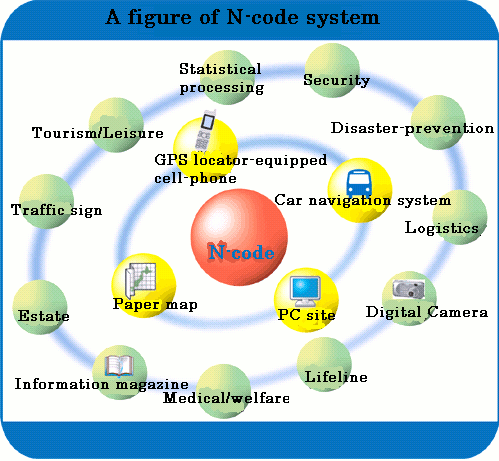
As indicated figure by, the location information of paper map, PC, cell-phone and car navigation can be unified. Therefore, many works and processes which are related with location information can be improved.
As mentioned above, N-code is not simply converted from decimal degree of latitude and longitude, it changes the coordinate structure using block, unit and mesh concept. Besides, it keeps consistency with latitude and longitude. The code is practical and strict which can calculate direction and distance with the digits depending on the usage.
|