|
|
The N-code Applications
The N-code can be applied for crime prevention, disaster prevention, traffic, sightseeing, for welfare, education and city planning, for company activity, academic research, etc. We introduce some useful applications.
1. Paper Map
-
An index of the conventional paper map is an index without the versatility such as A, B, C ..1, 2,3. Therefore, it can be used only in the paper map. Since the index of N-code is absolute based on latitude and longitude, N-code can be applied on various maps once the index is created.
2. Navigation System
-
The feature of the N-code navigator is that the destination can be designated at 5m accuracy with 8 digits. Therefore, you will not get lost around the destination.
-
The current position is indicated as a number, and not as a dot on the map, in case of accident, and you can easily tell you friend or JAF about your position.
-
It is easy to exchange the location information even if devices are different such as car navigation system and cell-phone navigation. It is useful for meeting up friends or other purpose
-
The links will be available between road maps and paper maps in the future.
3. Geographic Information System
-
Current location information is expressed as various ways such as address, place, object, latitude and longitude, 19 coordinate, etc. and it is not efficient. N-code makes it unified and efficient.
-
It is possible to unify the coordinate of GIS digital map and paper map, therefore, GIS information can be overlaid with paper map.
-
Participatory GIS, citizen and government can share the location information, makes GIS usage increase drastically.
GPS enabled Cell-phone
GPS enabled cell-phone is getting diffused in public. However, it is difficult for the user to understand the latitude and longitude directly. Therefore, there are problems. First is difficult to understand the place unless you change the scales. The other problem is that it is difficult to tell the position to other people.
N-code can display the current position digitally. Therefore, it can be applied on the following situations.
-
Recently, emergency calls such as 110 and 119 though cell-phone is increasing. Besides, there is a problem where EMS reaches late due to the difficulty in detecting the location. N-code makes it easier to inform about the current location.
-
Using N-code in emergency message or mail service can inform the current location easily and more precisely.
-
Location information exchange in case of rendezvous will be easier and more useful between cell-phone and car navigation system.
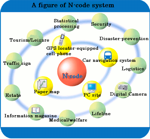
Other Application
Above 4 items makes location information unified based on N-code and can be used in various applications which are shown as below figure.
|